When I visited Germany, it sounded like a two-hour dive, each way, was an epic excursion. A four-hour drive, one way, was sheer insanity.
When I lived in Ontario, a two-hour drive, each way, was a big day trip. A five-hour drive, one way, was a long haul.
When I lived in Fort Liard, a two hour drive, each way, was a regular grocery run. A six-hour drive, one way, was a jaunt to the nearest (small) city. The scale is different here; communities are much, much farther apart and you get used to it. Actually, I really like it. Long-haul driving is really nice when your only traffic jams consist of herds of bison and flocks of stone sheep.
It was for that reason (that and the prohibitive cost of air travel) that I didn't think twice about driving the 2,400 mile (approx 3,900km) round-trip from Whitehorse, Yukon to Fort Smith, NWT so I could attend a graduation.
View Larger Map
It was a great trip. On the way there, including sleeps, I drove 1,200 miles (approx. 1,930 kms) in just under thirty-eight hours (sleeping in the back of the car along the way - station wagons rule!). I stopped just past Watson Lake, at Toad River, Fort Liard, and Hay River for food and fuel, but my first stop, just for the sake of getting out and stretching, was at Sambaa Deh Falls Territorial Park to take a look at the falls.

On the Liard Highway, looking upstream at the Sambaa Deh Falls.

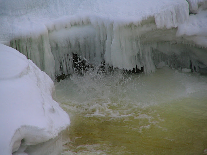
Water splurting out from under the ice.

Fossil-laden rocks, downstream of the bridge.

Looking down from the bridge rail.

Looking downstream at Sambaa Deh Falls.
My next stop was at the Kakisa River bridge. Right now, the speed limit across the bridge is 5km/h (3.1 mph). Yeah. It's almost impossible to keep my car going that slowly. The bridge has seen better days and is in the process of being replace. I couldn't slow down to 5km/h and not take the opportunity to get out and stretch. It was well past 20:00 and was starting to get dusky out, but I took some pictures anyway. When I walked onto the bridge, the speed-monitoring signs told me that I was going to fast. I promptly slowed my walking to 5 km/h.

Ice on the bank of the Kakisa River.

The Kakisa River, looking downstream.

Kakisa River Bridge - it has seen better days.

Getting soft in its old age.

Its bones are starting to show.

Slowest. Speed limit. Ever.
I stopped about 100 kms outside of Fort Smith, having managed to drive 870 miles (1,400 kms) in one day without ever once feeling sleepy or sore. The scenery was just too good and the driving was just too fun. Oh, and the best darned car seat I've ever had the pleasure of sitting in helped.
I slept in my car for the second night in a row and started early the next morning for the final leg into Fort Smith.

The final leg.

The power lines along the road were frequently used for nesting sites - it seemed like a third of the towers had large nests in them.
I'd never been to Fort Smith before, and quite liked it. It was not too big and not too small and had a lot of character and an abundance of service for a community its size, which shouldn't be surprising since it was once the capital of the Northwest Territories.
In addition to the graduation, I visited Wood Buffalo National Park, went to the rapids at Mountain Portage, ran into some friends who were also visiting the community, and dropped in on some old acquaintances who lived there.

The Fort Smith lunchtime rush-minute.

Wood Buffalo National Park interpretation sign. The Nyarling River, which the road passes, disappears into the ground before reemerging later on. Sinkholes, like this one (below) are made by underground rivers.

A big sinkhole.
When I arrived in Hay River, I phoned a few friends who were living there, but they were all at work or out of town.

The Norweta, a boat famous for its excursions in Great Slave Lake and down the Mackenzie River. I believe it's no longer offering its cruises, unfortunately.
Instead of waiting for the end of the working day in Hay River, I drove down to Enterprise where I visited, drank tea, spent the night (this time not in the car), and was generally spoiled rotten by friends who live there. That's one of the greatest things about the north, if you're there long enough to get to know people, you get to know people everywhere. One of the other great things about the north is its hospitality; there's never a twinkle of 5-star pretentiousness about it (it's almost always "rustic" and it's never "fancy"), but it's always genuine.

Looking northeast over an escarpment along the Mackenzie Highway.

A seemingly endless land.

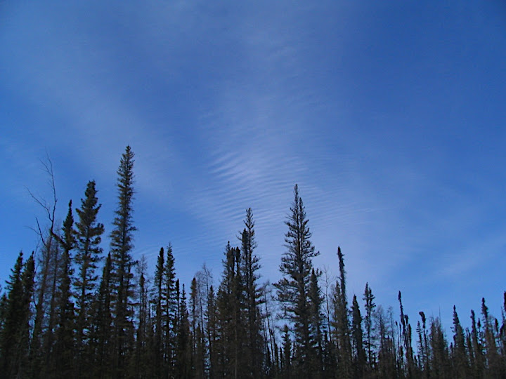
Cloud ripples in the sky along the Mackenzie Highway.

It reminds me of dried fish. Yum...dried fish...

The single-land bridge over the Poplar River on the Liard Highway. Or is the the Birch River Bridge? I always get those two mixed-up.

A view of the Liard Range from the Liard Highway.

Snow on the Poplar River. Or is that the Birch River..?

On the Liard Highway, getting closer to the Liard Range.

A nice guy, but he's somewhat accident prone. This new truck has been sitting by the side of the road all winter. It's going to need some work.
I stopped in Fort Liard again on the way back, this time with the intention of having a slightly longer visit. I did some visiting around town and then dropped by some friends for tea, but suddenly found myself savouring some freshly grilled moosemeat. Yum...
I could have spend the night in Fort Liard, but wanted to get back on the road and make as much distance as I could so the next day would be shorter.

Sundogs decorated the evening sky, just as I was about to get back on the road.

The Liard Highway, just north of the NWT/BC Border.
I slept in the car at a pullout at Summit Lake, the highest point on the Alaska Highway. There was an RV parked at the pullout, too. Spring has arrived; the RVs bring it with them.

The view out my window the next morning.

Just past Summit Lake. I SO want to go hiking up that valley someday.
I stopped for breakfast and fuel and gazed at the thousands of hats stapled to the walls and ceiling at Toad River, before pushing on to Teslin.

Funky snow-cat-type things at Toad River. Would they be better camouflaged if they were white?

Steam-moistened plants at the Liard Hotsprings.
After a good lunch in Teslin, it was a quick couple-hour hop back to Whitehorse. I got in just before Jade had to go to bed. Little kids make homecomings so much fun.
I'll be doing some more road trips this summer, but these ones will be work-related so I don't think I'll be able to bring the rest of the family along. Either way, I'll be sure to take lots of pictures and post the here.
If you haven't already, I hope that you get a chance to (take your time) and drive these highways. From what I've seen (and I've been around), there's nothing else like them.

On the Alaska Highway, returning to Whitehorse.
3 comments:
Now, that's what I call "meandering!" There's nothing as satisfying as a long road trip. And, how beautiful is that view of the Liard range!!
I hope only a couple of your photos were taken while you were driving. Not that there's much of any kind of traffic, but still!
The only one that was taken while driving was the one of my hand on the road to Fort Smith and that one was taken without looking at the viewfinder (you never know when a bison or moose or something else will jump out). Otherwise, all of the pictures were taken when stopped.
Hi Michael,
My name is Stevie and I work for an advertising agency in Vancouver, BC. The creative team has taken an interest in your writing and photographs and are hoping that you would be willing to upload your work to talesoftheyukon.ca. We love your adventures and think they would be great to showcase through the site! Please write back to me with your thoughts at wild.stevie@gmail.com.
Thanks,
Stevie Wild
Post a Comment