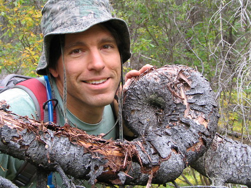
I've already visited N60o W132o, and I've had my eye on N60o W134o for a while. I was going to go last weekend, but decided that I really should finish the landscaping in front of the house, instead. Since I got the landscaping done, I decided that I was going to attempt the confluence this weekend.
On Thursday, Mike T, who had some hiking plans that fell through, gave me a call and I proposed that he join me on the confluence hunt. After all, why hike to some fantastically scenic location when you can bushwack to an imaginary point in the middle of nowhere?
Since the images on Google Earth weren't very clear, the topographic map I was able to pull off Toporama, the Atlas of Canada, came in handy for trip planning. There were things I didn't know: Was there a bridge across the Lubbock River? Was the road that showed on the maps bikeable?
Mike arrived Saturday morning and we loaded my canoe and our bikes on top of his vehicle. With our packs and dogs in the bak, we drove to the north end of Atlin Lake where we scouted for the access to the Lubbock River.
Our first attempt took us to Camp Yukon, which sits on the northern end of Atlin Lake, near the mouth of the Lubbock River. The friendly people there weren't aware of the road that led towards the confluence, so we unloaded the bikes to do some exploring. Picking up a promising trail, we followed it and ended up at the Hitching Post.
The owners of the Hitching Post weren't there, but we got the chance to chat with a nice gentleman who was living there for a while. He was a guide on the BC side in the Atlin area and probably knew that country like the back of his had, but he wasn't aware of the road on the maps. We asked if we could park our vehicle there for the day and he obliged.
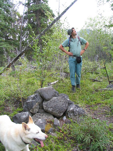
We biked back to the vehicle, loaded the bikes in the back, and drove around to the Hitching Post. We parked at the river bank and made what could possibly be the world's shortest portage to the river. Nanuq was eager to get into the canoe, and was proudly displaying to Mike and Lucky that he knew what to do. It was a very short ferry to the opposite shore, where we got out to see if we could find the remains of an old road. We found an old corral and a clearing with a trail up the middle. Grabbing our packs and pulling the canoe farther ashore, we began our trek inland. We were 10.6 km from the confluence, as the crow flies. And we weren't going to be flying like crows.
We followed the trail, which ran along a ridge, parallel to the end of the lake. Mike was picking wild cranberries as we went. The delicious berries were all over the place. I didn't say it, but I was tempted to just stop and spend the rest of the day picking the plentiful berries.
The trail faded out and, after some more walking, we found ourselves on the edge of a long, grassy marsh, which ran to our left and right as long as we could see. Getting our feet wet, we crossed the marsh and picked up a trail, following it in the direction we wanted. We followd the trail to a clearing, which looked like it was man-made, but lost the trail. Turning uphill and picking berries on the way we struck for higher ground and, hopefully, for a view of the surrounding terrain. On the way we saw saskatoon berries, soap berries, rose hips and more. It was a land of plenty.
We climbed out of a poplar forest and into some rocky ground that looked a lot like shield country in northern Ontario. Cresting the hill, we could see in the direction of our goal and it looked very distant, with masses of forested lowland in between.
Playing it by ear, we headed down the other side, hoping to pick up one of the roads marked on the map. We didn't, but we picked up a well-established footpath, though it was hard to determine if it was man-made or just heavily used by wildlife. Judging by the moose tracks, it seemed the latter was more likely.
We followed the braded trail through the trees and eventually into a large meadow. There was something about the meadow that just felt great. Maybe it was that we could walk where we were headed without having to wind around trees or through brush. Maybe it was the fantastic view of Mount Minto.
 "Ah, such a fine meadow."
We waded into the taller grass in the middle of the meadow and down to the end where we picked up another trail that, again, might have been man-made or moose-made, but, again, more likely the latter. We quickly lost the trail and started bushwacking again, though there was very little "whacking", the forest being quite easy to stroll through with few deadfalls and little undergrowth.
After half a kilometre, we emerged on a line that had obviously been cut some time ago. Although there was a footpath running down the centre, the willows and spruce had taken over the line. The line was running east-west. Had we picked up the road, or had we stumbled onto the 60th parallel? The GPS said we were "pretty-much" on the 60th parallel, but weren't really there. Had they made a mistake when they originally surveyed and cut the line?
We followed the line towards the confluence, but hesitated when we came to a split in the line. I voted to take the southern fork, which we did. We followed this until it forked again, and again, we took the southern fork. I was pretty certain at this point that the overgrown line was the road.
 "A clump of coral moss"
Walking along the footpath in the middle of the line with ease, we followed until the line came to abrupt end. The line had been working its way towards the south. We were lucky to pick up a trail off the end of the line. Judging by the old blazes, the axe-cut and winter-cut trees and the gentle winding of the trail, it seemed like we were on an old, and once well-maintained, trapline.
 "Twisty Tree"
We followed the trail until searching for blazes became more troublesome than it would be to just pick our own route through the trees. We were making good time now, and were less than four kilometres from the cache.
And then we hit the moraines. I'm not really sure that they were moraines, but from the air the ups and downs of the ground must have looked like the ridges of an accordion. It was frustrating to climb one ridge, only to descend and have to climb another over and over again.
We were gaining altitude, though. Making it to the height of land, we stopped to evaluate our options. The ground dropped off again into a valley, much larger than the accordion ridges we had been climbing. We were just over two kilometres from the confluence.
We took stock of the amount of time it had taken us to come this far and, seeing that the terrain ahead wasn't likely going to be easy, considered how much longer it would take to reach the confluence. And then there was the trip back. Sunset would be around 21:30. It wasn't likely we would make it back before sunset (at least, not with any addition time for errors or emergencies). We, albeit reluctantly, decided to turn back and try an new route on the way.
 "So near, yet so far. Time to turn back. It's so...sad!"
We started following one of the ridges downhill towards Minto Mountain and found ourselves in a very pleasant old burn. The trees were widely spaced apart with very little undergrowth in between. The sight and smell of the area reminded me of forest I'd seen in Arizona and California.
As we enjoyed the easy walking, we came across yet another trail. Judging by the caribou antler and caribou tracks, it was yet another heavily-used game trail. Only a single old blaze made us think otherwise.
The trail was taking us southwards, away from where we needed to go, but the walking was pleasant and we wanted to explore it some more. Was it an old Tlingit trail? Did it have something to do with the gold rushes in the area?
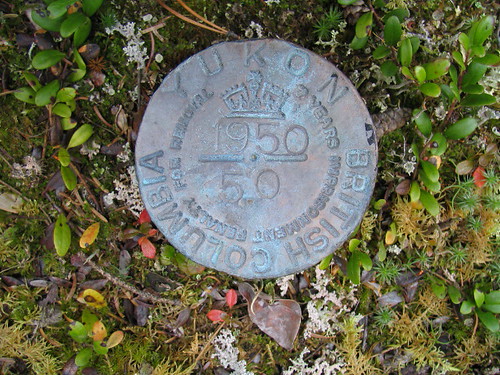
Mike almost walked right by it, but I froze to a halt at the cutline that stretched long and straight on either side. It was the 60th parallel. It had been cut long ago, but it was unmistakable. I consulted the GPS and it confirmed that it, while 55 metres off, was the 60th parallel. On one side we were in BC and on the other we were in the Yukon. We were border hoppers.
 "It's up there somewhere!"
We followed the cutline towards Atlin Lake, knowing that our goal was just two kilometres away in the opposite direction. The going was easy as we worked our way uphill.
There was a rock cairn at the height of land with more than a bit of lichen on it. There was also a metal post propped up by some rocks and two strange rectangles made of thin lodgepole pine, nailed in the corners. We didn't know what the rectangles were for. They can't have been very solid, but somebody must have made them for a reason.
 "Where did this cairn come from?"
The 60th parallel stretched to the east and we followed it. The trail headed downhill into some muskeg. If our feet were dry before, they weren't anymore. The muskeg seemed like slow-going, but were actually making good time. We could see where the ground climbed ahead of us and the pushed towards the easier-going dry land.
 "Only seven years imprisonment? It almost makes taking it worthwhile!"
Only it wasn't easier going. Giant boulders and deadfall from huge spruce trees littered the trail. Stepping over, under and around the deadfall, we crested the height of land again, but found the same think on the way down. Thinking that we might head north to pick up the road again, I turned on the GPS to get an idea of the distance, only the tall canopy, and possibly the cloud cover, blocked any chance I had of picking up a good signal. We headed downhill, seeing Atlin Lake below.
 "We're goin' that-a-way!"
Game trails started bisecting the cutline but one seemed a little different from the others. Not wanting to end up at the lake, we decided to investigate.
The log structure seemed out of place. It was a barn or stable of sorts, hewn from small logs, with stalls inside for a variety of animals. There were fences and old, non-mechanized farm equipment all around. I quickly picked up a signal on the GPS in the nicely cleared field. The field must have been larger at some point, but now the poplars was encroaching from the edges.
 "Mystery Barn"
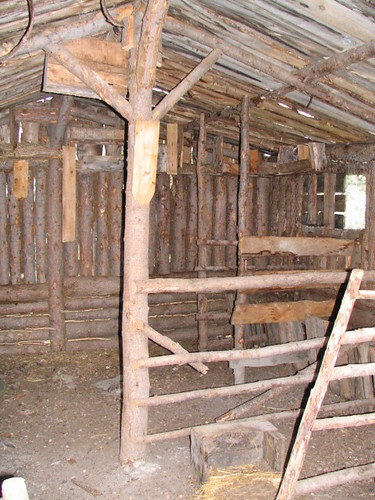 "Looks a little drafty"
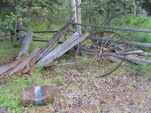 "Is sombody missing a wheel?"
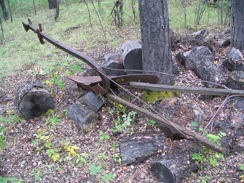 "Plow without an engine."
 "Hey, where did my scythe blade go?"
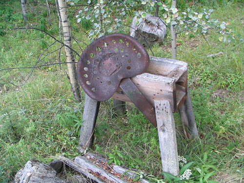 "More stuff, just lying around"
Our imaginations starting firing? Who made this place? When did they make it and, maybe more importantly, when did they leave? They had obvously put a lot of time and effort into clearing the land and they obvously used it, as evidenced by the row of rhubarb growing out of the grass - the remains of an old garden patch, perhaps. One thing bothered us about the site, however, and that was the absence of a residence. Maybe we didn't spend long enough looking, but we couldn't find one.
 "Somebody obviously took a lot of pride in this place."
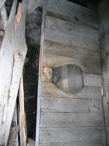 "I mean, look at that craftmanship!"
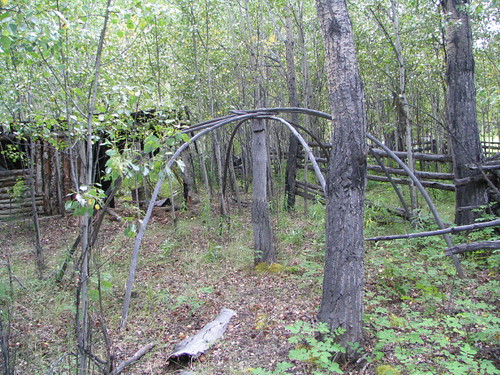 "It that the frame for a sweat lodge?"
 "Mike takes one last look before we push on."
We followed the clearings to a trail, which eventually took us past a camp/rest area, and down to the remains of a wooden landing on the shore of Atlin Lake. We picked up an old trail along the shore, but the deadfall made the going frustrating. I picked up an old, blazed trail inland and we followed it until the trail petered out. Yet again, we picked our own trail and met up with the overgrown road.
Through willows and swamp, and over deadfall, we followed the road out, taking us to the Lubbock River and the corral where we left the canoe.
We were wet and muddy up to our knees, but the dogs were wet and muddy up to their necks. We paddled across, forcing the dogs to swim.
We covered more than 20 kilometres, never stopping for more than a couple of minutes. We didn't make it to the confluence, but we got the lay of the land and found the routes that will make finding it easier next summer, when the days are a little bit longer.
We went out and we explored, and that is its own reward.
1 comment:
I'm the daughter in love of the man who built that homestead, and I just wanted to thank you for sharing the pictures...my kids will likely never get the opportunity to visit it, so it's nice to have a way to show them what their Grandpa's handiwork looked like!
Post a Comment